Wednesday, October 14, 2015

Mount Ijen

The crater of Mount Ijen is an active volcano located on the border between Banyuwangi and Bondowoso, East Java, Indonesia. This mountain has an altitude of 2,443 m and has several times erupted. The last eruption occurred in 1999. One of the most famous natural phenomenon of Mount Ijen crater is located at the peak. To climb this mountain to be departing from Banyuwangi or from Bondowoso.


Kawah Ijen is an acidic crater lake located on top of Mount Ijen with 2,443 meters high above sea level to a depth of 200 meters and a vast lake crater reached 5,466 hectares. Ijen crater lake known as a highly acidic lake water world [1]. Ijen crater is within the Park Reserve Travel Ijen, Banyuwangi, East Java. Every morning at around 02.00 until 04:00, around the crater can be found the phenomenon of blue or blue flame of fire, which is the uniqueness of this place, because the natural scenery of this only occurs in two places in the world, Iceland and Ijen. From the crater, we can see another mountain scenery in the complex Ijen Mountains, among which is the peak of Mount Merapi, which is located in the east of the crater, Mount roar, Mount Suket, Mountain Chain, and so on.


To reach the crater of Mount Ijen from Banyuwangi, could use economic train with the aim of Banyuwangi and get off at the station Karangasem then ride motorcycles with the purpose of sub-district and village Banyusari Slick. From Banyusari, proceed to Paltuding aboard trucks sulfur or use the bus and get off at Banyuwangi town then ride motorcycles can be directly to Paltuding or to the village of Banyusari can but using the bus fare incurred will be more expensive. The main gate to the Nature Reserve Park of the crater lies in Paltuding, which is also a Pos PHPA (Forest Protection and Nature Conservation). Alternative routes are Bondowoso - Wonosari - Tapen - Sempol - Paltuding. Other facilities that can be enjoyed by visitors include cottage and stalls selling purposes ascent to witness the beauty of Ijen crater.


From Paltuding walk a distance of about 3 km. Initial trajectory as far as 1.5 km quite heavy because of the uphill. Most of the lines are with a slope of 25-35 degrees. Besides uphill, too sandy soil structure so that adds to the growing weight of footsteps because they have to maintain their body weight in order to not slipped backwards. After resting at Bunder Post (a post which is unique because it has the shape of a circle), the next track is relatively slightly sloping, besides tourists / hikers treated to views of the mountain range is very beautiful. To get down to the crater must traverse the rocky terrain as far as 250 meters with a steep conditions.

Many events are often held, mainly by the Government of Banyuwangi are now in full swing to promote the crater in the list of tourist objects. Events that include: Tour de Ijen (now renamed 'International Tour de Ijen'), Jazz Ijen Banyuwangi, etc.

Natural phenomena Fire Blue "Blue Fire" in the crater

Fire as it is known for sure the color is red, then what if you want to see a different-colored flame, not red but blue and out of a crater. Is it conceivable you stand and watch this phenomenon with your own head, the moment of natural wonders unequaled. Very special to be missed because in the world there are only two phenomena that occur like this and one of them in Indonesia.


Crater is blue or blue fire, natural phenomenon which is unique and can only be seen in the crater - Banyuwangi only. Because of the beauty of this phenomenon popularity even beat the sunrise in Banyuwangi known as the first sun in Java. Not only that, many tourists from various countries willing to come all the way just to see the appearance of the Blue Flame in Ijen crater.

How to Achieve Blue Flame

Now what if you want to witness this phenomenon? The first thing you should do is to go first to Banyuwangi and everything by road using public bus transportation. You can reach the crater or mountain from two directions, namely, from the north or from the south. From the north, can be achieved through Situbondo towards Sempol (Bondowoso) through Wonosari and dilajutkan to Paltuding. Situbondo to Paltuding distance of about 93 km and can be reached about 2.5 hours.


While from the south can be passed from Banyuwangi towards Slippery within 15 Km. Of Slippery towards Paltuding within 18 Km and forwarded using a Jeep or other heavy car about 6 km before to Paltuding. This is because the roads are winding and uphill.

This area can be reached by public transportation from Banyuwangi towards Jambu.Dari Jambu, you can proceed to Park Reserve Travel Ijen Crater located in Paltuding using motorcycles and then continued on foot.

Tuesday, October 13, 2015

Klayar Beach Pacitan

Klayar beach is a beach with white sand and rocks and rock cliffs that surround. This beach is located in Pacitan, East Java and adjacent to Wonogiri, Central Java. Precisely located in the village of Kalak, sub Doonorojo, Pacitan. The distance is about 40 km to the west of the town of Pacitan. The beach is still in line with Ria Teleng beach that has been managed as a tourist spot in advance.


Klayar beach has a blue sea water and the waves were very large, so that visitors are not allowed to swim. Shoreline decorated plant coconut trees and huts / lincak-lincak roofed dry leaves, rocks tidal region is also still maintained naturally. Travelers also can down the rocks to find shellfish molluscs, and starfish Echinodermata.


Klayar charm charming panorama of the beach this is a viable thing you put in your travel plans. But please note that access to the beach is somewhat less easy. If you visit the beach Klayar Pacitan, you will find a section of the road has not been paved in their entirety as well as some parts are damaged.


In addition, you also have to pass through the winding streets and up and down, a thing that requires you to be more careful in driving. But on arrival at the beach, you will be presented with a beautiful view of the beach.


Tourist infrastructure problems have been anticipated by the local government and executed in Pacitan tourism development plan. Tourism development is quite important given the traffic visit the trip to the beach lovers Klayar Pacitan shows an upward trend over time.


Besides, also along the rock also contained limpets and seaweed that grows around bebatuan.Wisatawan can see directly the local community in order to climb coconut trees taken deresan water (raw material for the manufacture of sugar), or simply to be presented directly to tourists while enjoying the exotic nature beach Klayar.

Travel route to Klayar Beach Pacitan

Until now, not yet available public transportation that can take you to the beach Klayar Pacitan. The most popular way to the beach is by private vehicle, whether car or motorbike. Some tourists also use the services of travel agencies to deliver the group headed to the beach this Klayar. Keep in mind, of Goa Gong Pacitan to Klayar beach is so far only about 12 km.

Mount Jayawijaya

Jayawijaya Mountains is the name for the mountain range that lies lengthwise in the middle of the province of West Papua and Papua (Indonesia) to Papua New Guinea Newguinea Island. Rows of mountains that has some the highest peak in Indonesia is formed by removal of the sea floor thousands of years ago. Although located at an altitude of 4,800 meters above sea level, fossilized sea shells, for example, can be seen on the limestone and clastic contained in Jayawijaya Mountains. Therefore, apart from being a paradise for sport climbers, Jayawijaya Mountains is also a paradise for geologists world of special interest.


This is the highest peak in Indonesia and Oceania, the Puncak Jaya. This peak is also known as a popular peak Cartenz which has an altitude of 4,884 meters above sea level. It lies in a line which is located in the Sudirman Mountains Maoke Mountains, Papua.

Puncak Jaya or Carstensz Pyramid is included in the list of 7 Summit or seven highest peaks in the world. At the peak of this is still the only region that still enveloped in snow even so broad blanket of snow is also diminishing from year to year.


Jayawijaya mountains is a mountain range that lies in the middle of the province of West Papua and Papua (Indonesia) to Papua New Guinea on the island of New Guinea. There are 6 peaks in mountainous Jayawijaya: Puncak Jaya (formerly Peak Carstensz Pyramide), Meren Peak, Peak Northwall, Ngga Pulu Peak, Peak Sudirman, and Puncak Trikora. Peaks with permanent snow exists only in four of the first peak. But unfortunately this eternal snow began to melt due to global climate change.

Of the six peaks of these mountains, Puncak Jaya is the highest peak at 4,884 meters above sea level (masl). Even Jayawijaya mountain peak known as one of the top seven continents. But you know that the so-called peak of the continent was once the ocean floor? The proof of various fossils of sea shells found in the top of the mountain. So the dream to the tops pegungungan Jayawijaya not only climbers, but also geologists world.


Apparently 60 million years ago the island of Papua is still on the seabed formed by sedimentary rocks. A short story in time millions of years going on various tectonic activity and deposition produces the mainland of Papua is still fused with Australia. Gradually this inland fragmented and produce islands and mountains in Papua as we know it today.

There are still many secrets Jayawijaya rocks that are untapped and there are still many who have never climbed the highest peak in Indonesia. So you choose which one? So the researchers rock climbers accomplished or famous? Both can be done in Jayawijaya Mountains.


Jayawijaya mountains are also the only mountains and mountain in Indonesia has peaks covered by eternal snow. Although not all of the cluster of Jayawijaya Mountains peak that has snow. Snow owned by some of the top even when it has been lost due to changes in global weather.

According to geological theory, originally the world only has a continent called Pangea at 250 million years ago. Continent Pangea split into two to form the continents Laurasia and the Eurasian continent. Eurasian continent broke back into the continent Gonwana which would later become the mainland of South America, Africa, India, and Australia.

At the peak of the highest mountain in Indonesia, snow was spread. The altitude that reaches 4,884 dapl make any lasting snow covered mountain peak in Papua. The snow at the top Jayawijaya is one of the unique natural phenomenon, because natural ice usually does not go down along the equator. If viewed from the air, Puncak Jayawijaya like tapestry covered with white hood. If the sun is bright, the snow will reflect sunlight glare but still awesome.


The beauty of the peaks Jayawijaya or better known as the climbers as the Carstensz Pyramid is listed as one of the top seven continents (seven summit) which is phenomenal and the target of mountaineers in various parts of the world. Carstenz taken from the name of the inventor of these mountains, Jan. Carstenz who see the snowy peaks in the tropics through an ocean liner in 1623.

Being in Puncak Jayawijaya or Carstensz Peak is a mountain climber's dream. Requirements are not easy and the cost is not cheap even have to be prepared ahead of time in order to overcome various obstacles. Starting from the natural conditions that are so steep, very cold temperatures, and strong winds and possible lack of oxygen is a challenge.

Parangtritis Beach

Parangtritis is the most popular beach in Yogyakarta. Parangtritis located 27 km south of Yogyakarta. Parangtritis is a beach full of myths, believed to be a manifestation of the unity among which is composed of Mount Merapi, Yogyakarta Kingdom and Parangtritis.


Parangtritis located 27 km south of Yogyakarta and easily accessible by public transport which operates until 17:00 pk or private vehicles. The afternoon before sunset is the best time to visit the most popular beach in Yogyakarta. But if you arrive more quickly, it could not hurt to go up to the cliffs of Gembirawati behind this beach. From there we could see the entire area Parangtritis, the southern sea, up to the horizon.


Not many people know that in the east cliff is hidden a temple ruins. Unlike the other temples located in a mountainous area, Temple Gembirawati just a few hundred meters from Parangtritis. To reach this temple, we can pass the ramp near the Hotel Queen of the South and into the walkway to the west about 100 meters. The faint rumble south ferocious sea waves can be heard from this temple.

Parangtritis very closely with the legend of the Queen of South. Many Javanese believe that Parangtritis is a magical kingdom Ratu Kidul gate which controls the southern ocean. Hotel Queen of the South is a resort named after this legend. Unfortunately this resort is rarely open when used to have a view that could make us breathless.


Parangtritis is a fairly well-known attractions in Yogyakarta apart from other beach objects such as Samas, Baron, Kukup, Krakal and Glagah. Parangtritis has a unique view not found in other attractions are in addition to big waves and also the mountains of sand around the beach, which is commonly called dunes. This attraction has been managed by the Bantul regency quite well, ranging from lodging facilities and a market selling souvenirs Parangtritis.


Parang there are also ATV, horse-drawn carriage and horses can be hired to down the coast from east to west. In addition Parangtritis is also a place for air sports / aeromodeling.
When the sun has been biased toward the west and the sunny weather, it's time to have fun. Although visitors are prohibited from swimming, Parangtritis not lack the means to having fun. On the beach there are rental ATVs (All-Terrain Vehicle), the tariff is Rp. 50,000 to 100,000 per half hour. Enter his gear and then release the clutch while pulling gas. Brrrrooom, four-wheeled all-terrain motorcycles will be sped take you across the sand dune beach.


Well, ATV may only be suitable for those who are adventurous. Another option is the gig. Along the surface of the waves washed the sand smooth with hansom 2 is no less enjoyable. The buggy will take us to the east end Parangtritis place so beautiful cluster of coral spot often used as a pre-wedding photo shoot. Twilight dim golden sun and shadow on the surface of water even evoke a romantic atmosphere.

Parangtritis also offers excitement for those who traveled with family. Kite flying with your baby is equally enjoyable. Very strong sea breeze helps to make a kite flying high, even if you have never played a kite though.


Still reluctant to return even though the sun had set? Soon some roasted corn sellers will hold a mat on the beach, we could hang out there until late at night. Still did not want to go home? Do not worry, in Parangtritis available dozens of inns and lodging at an affordable price.

In addition there is a bath called Parangwedang. It is said that the water in these baths can cure various diseases among them skin diseases because water from these baths containing sulfur. Hot water from Parangwedang also flowed into Parangtritis to rinse after playing the sand and also irrigate a small pool playing children.

Prambanan Temple

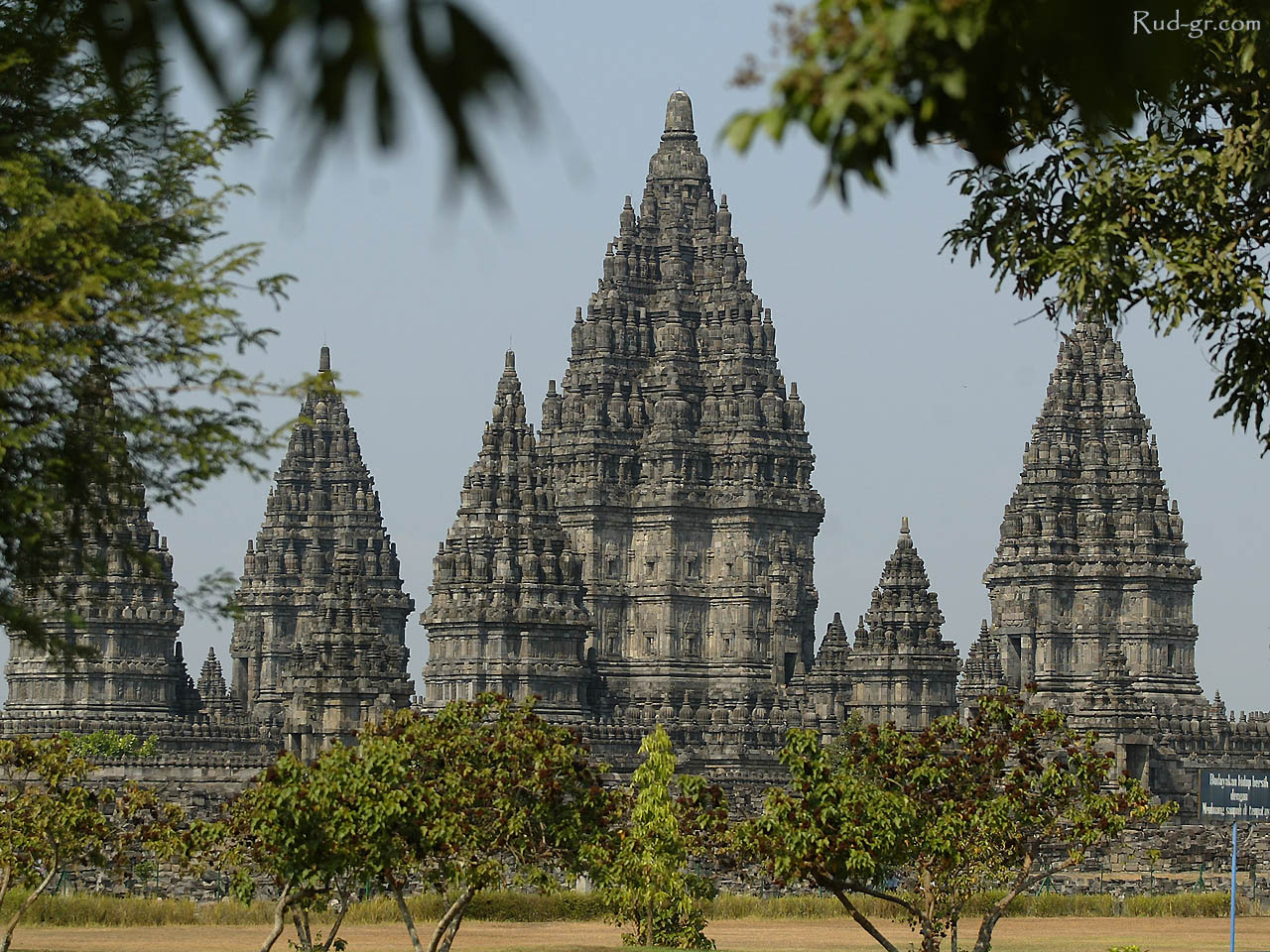
Candi Prambanan or Loro Jonggrang is the largest Hindu temple complex in Indonesia, which was built in the 9th century BC. This temple is dedicated to Trimurti, the three main Hindu gods Brahma as the creator god, Vishnu as the preserver god, and Shiva as a god of destruction. Based on the inscriptions Siwagrha original name of this temple complex is Siwagrha (Sanskrit which means 'house of Shiva'), and indeed in garbagriha (main hall) of the temple sits a statue of Shiva Mahadeva three meters high which shows that in this temple of Lord Shiva are preferred.


The temple complex is located in the district of Prambanan, Sleman and sub Prambanan, Klaten, approximately 17 kilometers northeast of Yogyakarta, 50 kilometers southwest of Surakarta and 120 kilometers south of Semarang, exactly on the border between the provinces of Central Java and Yogyakarta. It is very unique, Prambanan temple is located in the administrative area Bokoharjo village, Prambanan, Sleman, while the entrance to the Prambanan temple complex located in the village administration Tlogo, Prambanan, Klaten.


Name Prambanan is derived from the name of the village where the temple stands, believed to be the change of the name of the dialect of Javanese language of the term theology Hindu Para Brahman means "Brahman Supreme" is Brahman or the eternal realities highest and greatest that can not be described, which is often equated with the concept of God in Hindu religion. Another opinion considers the Brahman may refer to the heyday of the temple was formerly filled by brahmins. Another opinion put forward the notion that the name "Prambanan" comes from the root word mban in the Java language that is meaningful to bear or have a task, refer to the Hindu gods who took on the task to organize and run the harmony of the universe.


The original name of this Hindu temple complex is the name of Sanskrit; Siwagrha (House of Shiva) or Siwalaya (Natural Shiva), based shivagrha inscription which is dated 778 Saka (856 AD). Trimurti glorified in this temple complex of three main temples venerate Brahma, Shiva and Vishnu. But Shiva Mahadeva who occupy the main hall in the temple of Shiva is the god most venerated in this temple complex.


This temple is including the UNESCO World Heritage Site, the largest Hindu temple in Indonesia, and one of the most beautiful temples in Southeast Asia. The architecture of the building is tall and slender shape in accordance with Hindu architecture in general with the Shiva temple as the main temple has a height reached 47 meters towering in the middle of the complex cluster of temples are smaller. As one of the grandest temples in Southeast Asia, Prambanan temple is the main attraction of tourists visiting from all over the world.


According to the inscription Siwagrha, this temple was built in about 850 BC by Rakai Pikatan, and continue to be developed and expanded by Balitung Maha Sambu, during Medang Mataram kingdom.

Madakaripura Waterfall

Madakaripura waterfall is a waterfall located in District Lumbang, Probolinggo. This waterfall is one of the waterfalls in the Bromo Tengger Semeru National Park. 200-meter high waterfall is the highest waterfall on the island of Java and the second highest in Indonesia. Madakaripura waterfall-shaped recess surrounded by hills dripping in all areas of the ridge like raining, 3 of them even formed a waterfall pouring again.


Madakaripura visit the waterfall is one of the things that must be done by the explorers who went to East Java. Madakaripura can be reached from Malang or Probolinggo. From Probolinggo you can ride a big bus towards Tongas. You can express your goals for the conductor that you want to visit the waterfall and you will be laid off at the junction Tongas. Once down, you have to continue the journey by public transportation before you have to bargain.


The journey from Tongas to Madakaripura full of nice scenery and also the road which was quite uncomfortable. But all that would be paid if the explorers had reached the gate Madakaripura. There is no admission but you will be offered the services of a local guide who can bring you a carrier bag when needed. The journey from here to the waterfall is very beautiful and indulgent eye with a view of the big trees, the fresh air and also pass through the rivers. Sturdy shoes, waterproof sandals or mountain strongly recommended for this trip. 

Trips take approximately 1 hour when later you feel the cold around and also water bounding into your body. Therefore, a change of clothes, a raincoat or umbrella is strongly recommended. You have to walk a little further to enjoy the waterfall headliner. You still have to climb the cliffs are quite slippery and narrow. But once again it will be paid off so you see the main waterfall which berdinging circular, so it looks like you are in the bottle. Very beautiful.

Myth gained from Niagara Madakaripura is recommended that you leave this place before 14.00. Will often occur during the hours of rain that could affect the water level around the waterfall that is quite dangerous and difficult lets you leave the place.


After enjoying Madakaripura, you can return to Tongas and then to Probolinggo. Or you can continue the journey to Mount Bromo.

Noteworthy: For beginners who first visited these attractions must be very careful, because this location is utilized irresponsible elements. for example if we entrust the goods in the stalls around the parking lot, it is not uncommon our goods unloaded at the shop keeper, the other mode is suddenly escorted us to the tourist sites, but stayed way 30 minutes following a path to get to the waterfall (who later asked for money services mengngantar), and again fitting we return from tourist sites suddenly there who admit the motor we've washed (when cuman flushing water wrote and still dirty), and they ask for money to wash service motor that he has included travel policy. Be a save trip.


The waterfall is named from Madakaripura, fief belonging mahapatih Gajah Mada of Majapahit kingdom.

Sanur Beach Bali

This beach is located in the east of the city of Denpasar. This beautiful beach is often used as the location for surfing by foreign tourists. In addition, tourists usually visit the Museum Le Mayeur. This beach is suitable for watching the sunrise because of its location in the eastern part. Meanwhile, according Kuta Beach to see the sunset.


Sanur beach is one of the beaches on the island of Bali are worth visiting. The beauty of its natural scenery make the Sanur Beach is famous even since antiquity. In the history of ancient Bali, Sanur Beach has been known as a beautiful beach, it appears the inscription King Kasari Warmadewa, a king who berkeraton in Singhadwala in the year 917 AD Now, the inscription contained in Blanjong area, the southern part of Sanur Beach.

In the Dutch colonial period, Sanur Beach is famous as the landing site when the Dutch army will attack the Kingdom of Badung considered defying the colonial government. The war that occurred on 18 November 1906 it became known sebagaiPuputan Badung, the spirit of war to the death practiced by the King of Badung and his followers.


In terms of tourism, Sanur Beach began to be introduced to the international world by AJ Le Mayeur, a painter from Belgium who came to Bali in 1932. Seeing the appeal very beautiful Sanur Beach, Le Mayeur then decided to settle in Sanur by establishing a painting studio. Le Mayeur then married a Balinese girl named Ni Nyoman Pollok, a famous Legong dancer and is one model of his paintings. Through paintings Le Mayeur, Sanur Beach began to be known by the international community. Currently, the painting studios have become Museum Le Mayeur and can be visited by the public. Le Mayeur Museum is located in the tourist area of ​​Sanur Beach.


In contrast to Kuta Beach which presents the beauty of the sunset (sunset), Sanur Beach is famous for its panoramic beauty of the sun rising of (sunrise). The topography of the curve with white sand that stretches form a cluster of beautiful beaches. In the morning, while enjoying the moments publication dazzling sun, tourists can witness the islands of Nusa Penida in the southeast and a panoramic south coast of the island of Bali.


The scenery in the afternoon is equally interesting. Receding tides clarify eyes on Serangan Island and hills cluster of rocks jutting into the sea in the south of Sanur Beach. Not only that, if the waves are not so great, tourists can witness the beauty of the coral reef that stretches colorful.

Sanur beach is located in the village of Sanur, Denpasar District, Denpasar, Bali Province. Sanur beach is about 6 km from Denpasar city center and can be reached by private vehicle such as a car or a motorcycle. If you want to use a common vehicle (minibus), tourists need not worry because public transport is very crowded fro between Sanur-Denpasar.


Sanur area is the region's first tourism development in Bali, characterized by the presence of the luxury hotels and various restaurants. Therefore, tourists do not need to worry if needed lodging or food stalls around this beach. In addition, the tourist area of ​​Sanur Beach also provides souvenir stalls selling various goods art and souvenirs typical of the coast.